fbpx

Drift Creek Falls Hike- Oregon’s Most Surprising Hike

DISCLAIMER: Our posts may contain affiliate links. If you click through and make a purchase, we may receive commission. You won't pay more, but you will be providing us with a small commission, which helps to keep the lights on. All recommendations are based on our own opinions and preferences. You can read our complete disclaimer here. Thanks!

  • Save

The Drift Creek Falls hike winds through a dense, damp forest. Ferns carpet the ground, blanketing everything in shades of green. As you walk, the hike may seem to be leading you in endless circles, but soon enough, the forest’s secret is revealed.

About Drift Creek Falls
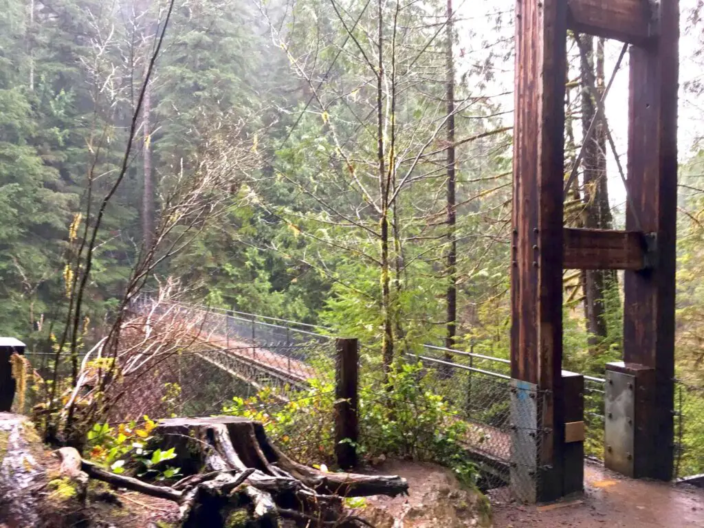
supspension bridge at Drift Creek Falls hike.
  • Save

Located in Oregon’s Siuslaw National Forest, this 3 mile out-and-back style trail winds through regrowth forests and over small footbridges with trickling creeks below. The wet, wide, and well maintained trail offers an easy downward slope, on the way in. But be prepared to climb that slope on the way back to your car.

One and a half miles down the winding, dense, and sloping trail you will suddenly stumble upon a 240-foot suspension bridge. Hanging 100 feet above the river below, the Drift Creek Falls suspension bridge offers a unique view of Drift Creek Falls Oregon. We had seen photos of the bridge online, but nothing can prepare you for the immense size and shock of seeing it the first time. I felt completely in awe seeing how out of place the bridge seems, but yet, it seamlessly blends with the landscape.

Top view of Drift Creek Falls suspension bridge along with view of support beams
  • Save

Built in 1997, the 3-foot wide suspension bridge is supported by large cables anchored into the bluffs on either side of the bridge. The slight sway as you venture across it adds an extra element of suspense that I did not care for.

The closer you walk to the bridge, the louder the sound of rushing water becomes. And once on the bridge, Drift Creek Falls will be in full view. The powerful rushing water hitting the rocks creates a calming background noise as you look at the river 100 feet below.

As you walk across the bridge, if you can bear it, take a moment to snap photos and enjoy the view. During our rainy trip, we encountered a few other hikers, but it is not uncommon for the bridge to be cramped with hikers.

Once you have taken in all the views from the bridge vantage point on your Drift Creek Falls hike, we suggest you walk the additional ¼ mile to the base Drift Creek Falls. From there, you will find a fantastic photo opportunity of the falling water with the suspension bridge in the backdrop.

This is also a great place to stop and enjoy lunch at one of the nearby picnic tables, or cast a line in and see what fish you can catch. Just be sure to follow Oregon’s fishing rules.

The Drift Creek Falls Hike Secondary Trail

If you are looking for a way to expand the Drift Creek Falls Hike experience, try the north trail. After some small bridges on the main trail, well before the suspension bridge, there is a fork in thepath.

If you opt to take the North Trail, which is 0.8 miles long, it will lead you to and through an old growth forest. This trail can be quite muddy, but is often less crowded and can make for a more peaceful hiking experience.

After 0.8 miles, the north trail connects back to the main trail so you can continue on your journey.

Directions to Drift Creek Falls Hike Trailhead

A view of the falls from on top of the bridge
  • Save

To find the Drift Creek Falls hike trailhead, which is located in Otis Oregon, head to the junction of Oregon Highway 18 and Highway 101. From there, travel 4.5 miles down highway 18 then turn south on Bear Creek County Road. After three and a half miles, turn onto Forest Service road 17. Continue 7 miles to the trail head.

In the past, the Drift Creek Falls hike was easy to access from Lincoln City, but a recent rockslide has closed the road which provided access. Now, you can only access the trailhead from the north, as described above.

Things to Know Before You Go

At the Drift Creek Falls hike trailhead, there is a restroom, and a hike information sign where you place your $5 parking fee.

Plan to spend 2-3 hours on this hike, but add an additional hour if you plan to add the northern trail to your journey.

The trail is open year round during daylight hours and well behaved, leashed pets are allowed.

Be aware that the Drift Creek Falls hike can be crowded on weekends. The parking lot is small and can only hold about 20 cars. On busy days with warm weather, plan to arrive early to score a parking space and avoid crowds.

Expanding the Journey, What to See Nearby

Drift Creek Covered Bridge has been restored
  • Save

For an additional piece of history while hiking Oregon, make sure to stop and see the Drift Creek Covered Bridge about one mile down Bear Creek County Rd. Built in 1914, this covered bridge is the oldest one in Oregon. It was used on the main north/south route along the Oregon Coast.

By the 1960’s the automobile traffic had been rerouted to a concrete bridge and the Drift Creek Bridge was used for pedestrian only traffic. In 1988 the bridge was deemed unsafe and closed to all traffic. It was dismantled in 1997 and moved to its current spot on Bear Creek County Rd.

If you are heading to Drift Creek Falls hike from the Corvallis or the surrounding area, take the Kings Valley Highway to Lincoln City for some additional sightseeing.

If you take Highway 20 out of Corvallis to Highway 223, you’ll find a small roadside spring between mileposts 15 and 16. Here, you will find fresh, cool, and clean water coming from a small rock outcropping. The locals often stop here to fill up jugs for remarkable tasting drinking water. Coming from the south, the spring is on your left directly after a curve in the road. There is a small gravel parking lot on the opposite side where you can park.
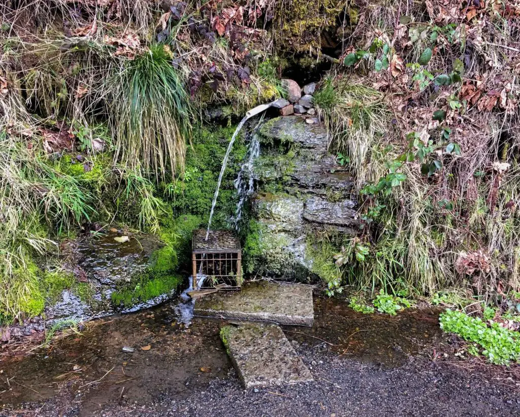
spring near Drift Creek Falls hike.
  • Save

About 5 miles after the spring, in the small town of Peedee, Oregon, you’ll find another covered bridge on your right. The Ritner Creek Bridge was built in 1926 and was almost destroyed in 1974. The community came together to raise the funds to save and refurbish the bridge.

THINGS TO DO NEARBY

Chinook Winds Casino Resort– 38 minutes away

Kyllo’s Seafood and Grill– 38 minutes away

Small roadside spring- see above

  • Save

Ali Patton

Ali is a travel blogger for Seconds to Go, where she shares her experiences traveling the U.S. with her co-blogger Mom, Kathleen. She is also an avid Disney travel enthusiast, and with multiple Disney World trips under her belt, is a knoweldgeable resource for all things related to Disney vacations. Ali can be found managing the Seconds to Go social media accounts as well as the famed Double Z Farm pages on Instagram, Facebook and TikTok.

Thanks for Joining Our Adventure

Kathleen Hesketh and Ali Patton, mother daughter travel bloggers

We're Kat and Ali, a pair of mother-daughter travel bloggers exploring the U.S. We're sharing our experiences, tips and insights to help you more easily get out and explore the beautiful landscapes and places of this nation.

FOLLOW US

pinterest icon
Instagram icon
Facebook icon
Twitter
follow us in feedly

#Seconds2go

More Adventures

peter iredaleoptimized
  • Save

Wreck of the Peter Iredale, Haunting Shipwreck on the Oregon Coast

February 27, 2024

Share via: 372 Shares Pinterest 304 Facebook 68 Twitter 0 Reddit 0 Mix 0 Flipboard 0 LinkedIn 0 Email 0 Pocket 0 Tumblr 0 The Oregon coast is home to rich and varied habitats as well as unique glimpses into history, and that’s where the wreck of the Peter Iredale fits right in. The Peter … Read more

Aussie dog standing in front of the Painted Hills
  • Save

Painted Hills State Park- Created by Mother Nature’s Paintbrush

February 22, 2024

Share via: 94 Shares Pinterest 94 Facebook 0 Twitter 0 Reddit 0 Mix 0 Flipboard 0 LinkedIn 0 Email 0 Pocket 0 Tumblr 0 Rolling Hills in sunset colors spread across the desert landscape of the Painted Hills State Park, part of the John Day Fossil Beds National Monument in Oregon. They offer a beautiful … Read more

Tillamook Air Museum
  • Save

Tillamook Air Museum- the Almost Forgotten War History

February 21, 2024

Share via: 287 Shares Pinterest 227 Facebook 60 Twitter 0 Reddit 0 Mix 0 Flipboard 0 LinkedIn 0 Email 0 Pocket 0 Tumblr 0 DISCLAIMER: Our posts may contain affiliate links. If you click through and make a purchase, you won’t pay a penny more, but we’ll get a small commission, which helps to keep … Read more

exterior of living rock museum, Oregon's museum dedicated to stone art.
  • Save

Living Rock Studios, Chiseling Oregon Art from Stone

February 12, 2024

Share via: 476 Shares Pinterest 417 Facebook 59 Twitter 0 Reddit 0 Mix 0 Flipboard 0 LinkedIn 0 Email 0 Pocket 0 Tumblr 0 Nestled into a forgotten corridor of the Over the River and Through the Woods Scenic Byway is Oregon’s Living Rock Studios one of the most unique things we’ve found to do … Read more

airline baggage carousel black bags
  • Save

8 Ways to Make Your Luggage Stand Out When Traveling

January 12, 2024

Share via: 158 Shares Pinterest 158 Facebook 0 Twitter 0 Reddit 0 Mix 0 Flipboard 0 LinkedIn 0 Email 0 Pocket 0 Tumblr 0 While flying can be the most convenient way to travel, let’s face it – the baggage claim can process is always a bit of a headache. Ever noticed how most suitcases … Read more

Trail of Molten Lands Featured image
  • Save

The Trail of the Molten Land- Newberry Volcano

August 24, 2023

Share via: 2.4K Shares Pinterest 2.4K Facebook 0 Twitter 0 Reddit 0 Mix 0 Flipboard 0 LinkedIn 0 Email 0 Pocket 0 Tumblr 0 The Trail of the Molten Land, located outside of Bend, is an easy trail that brings hikers to an alien planet. In reality, you stroll through a roughly one-mile of lava … Read more

IMG 6153 1
  • Save

Trekking the Shimmering Path: A Guide to Oregon’s Big Obsidian Flow Trail

August 16, 2023

Share via: 297 Shares Pinterest 297 Facebook 0 Twitter 0 Reddit 0 Mix 0 Flipboard 0 LinkedIn 0 Email 0 Pocket 0 Tumblr 0 The Bog Obsidian Flow Trail winds through the youngest lava flow in Oregon. The roughly one square mile area is made up of glossy black obsidian and pumice stone. This hike … Read more

Newberry National Volcanic Monument featured image
  • Save

Nature’s Raw Power on Display: Exploring the Geologic Wonders of Newberry Volcanic Monument

July 19, 2023

Share via: 144 Shares Pinterest 144 Facebook 0 Twitter 0 Reddit 0 Mix 0 Flipboard 0 LinkedIn 0 Email 0 Pocket 0 Tumblr 0 The Newberry National Volcanic Monument in central Oregon combines 54,000 acres of land to feature lakes, lava flows, lava tubes, unique geologic formations, and some of the best views of the … Read more

two women in shadow inside a lava tube cave in central Oregon
  • Save

Descending into the Abyss at Lava River Cave Oregon

July 9, 2023

Share via: 297 Shares Pinterest 297 Facebook 0 Twitter 0 Reddit 0 Mix 0 Flipboard 0 LinkedIn 0 Email 0 Pocket 0 Tumblr 0 Even as you’re descending into the giant maw of Lava River Cave near Bend Oregon, you’re thinking the usual thoughts that accompany steps into the subterranean. Will I see stalactites or … Read more

Lava cast Forest featured image
  • Save

Oregon’s Lava Cast Forest: Nature’s Sculpture Garden in the Heart of the Pacific Northwest

June 28, 2023

Share via: 216 Shares Pinterest 216 Facebook 0 Twitter 0 Reddit 0 Mix 0 Flipboard 0 LinkedIn 0 Email 0 Pocket 0 Tumblr 0 Oregon’s lava cast forest is located in the Newberry National Volcanic Monument and features an important remnant of the Earth’s early volcanic history. Hikers of all abilities can enjoy the paved … Read more