ATTENTION: As of December 2023, the U.S. Department of the Interior Bureau of Land Management has closed the Valley of the Giants to Public Access due to flooding of the North Fork Siletz River. The resulting debris flow has obliterated the roadway to the area and is predicted to take years to salvage. Please consider the following alternative hikes or Oregon activities instead:


Original article starts here
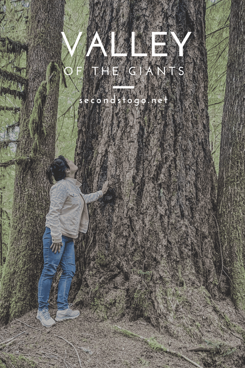
When it comes to visiting the Pacific Northwest, adventurers have a lot of choices, but none are as humbling as the Valley of the Giants, Oregon trail near the now defunct town of Siletz. Accessing this special, sacred old growth grove requires an intrepid spirit, perseverance, and if traveling on a weekday, possibly a death wish.
Table of contents
Taking the Valley of the Giants Trail

Getting to Oregon’s Valley of the Giants is an adventure in itself, requiring deft navigation skills and knowledge of logging road etiquette. Once you reach the trailhead, however, a sublime sense of peace and purpose rapidly descends.
The 51 acres that comprise the Valley of the Giants are tucked serenely between the North Fork of the Siletz River and Warnicke Creek, where a BLM Outstanding Natural Area designation has protected 400-year old giants from the ax since 1976. In that time, many of the giants have reached 200 feet tall and measure a whopping 20 feet in circumference.
Some of the largest have failed the test of time. One Douglas fir known as Big Guy, lost its footing and felt to the ground in a 1981 windstorm. While not the largest tree in the state, he is the giant of the fallen heroes within the forest. Lying just shy of 230 feet, his length is bested only by his diameter, over 11 feet at chest height.
It’s hard to admit, but entering the Valley of the Giants was a bit underwhelming at first.
A gentle trail meanders downhill beyond large beauties that rival specimens dotting the Hackleman Old Growth Trail in the Willamette National Forest. Maybe it’s a test of trust to let visitors wander through the youngsters first, determining your mettle before the giants begin to quietly step into your path. For us, the biggest of the big came out to play once we’d crossed the bridge that provides portage over the North Fork.
From here, the Valley of the Giants trail veers in and around massive trunks, sheltering us from the sun that had just begun to burn off the fog on its maiden appearance of the day. It’s eerily quiet beneath the boughs, but soothing, calm. It’s a chance to see how early settlers felt claiming this land and a rare treat to witness the awe-inspiring beauty that must have met their footsteps at every turn.
In search of the Big Guy, we stop first at another fallen hero, nearly mistaking its massive girth for the largest of the felled trees. It’s not a mistake we could labor under for long, however, as the trail literally leads right through a portion of Big Guy’s trunk, conveniently cut just wide enough for a person to slide through.


The trail dips reverently to honor his passing and the forest begins to change. The massive trunks thin out, letting light reach the floor. Greenery appears, and a fairy forest emerges alive with sun- speckled leaves.

We’ve reached the home stretch of the Valley of the Giants trail by this point, and the largest of the giants begin to wave goodbye as younger guardians step forward to take their place. They escort us through the final quarter mile or so, not small trees by ordinary standards, but within the Valley of the Giants in Oregon, they still have plenty of time to grow up.
Soon, the lollipop loop comes to an end, leaving us on the Oregon roadside. I have to tamp down the urge to retrace my steps and make the journey again. I’m certain there were sights that I missed, giants that I have yet to visit. But the family is waiting, stomping dirt and pine needles from shoes and loading up the car for the long trip back down gravel roads.
It’s hard to say goodbye to a magical place like this but leaving is what protects the Giants for future generations.
Visiting Valley of the Giants in Oregon

The trailhead to the Valley of the Giants in Oregon is located at Latitude: 44.93632 Longitude: -123.71554. However, the BLM strongly recommends contacting their office either by calling or visiting BLM’s Salem District Office, before heading out.
Here, you’ll be provided with an up-to-date map and mile-by-mile directions, including routes to take to avoid closed roads or those blocked by snow, fire or wash out. Since many of the roads leading to the Valley of the Giants are on private land, they can be closed at any time. The BLM is the most up-to-date source of information.
Valley of the Giants Oregon Driving Directions
When it comes to backwoods Oregon and logging roads, we have an ace in the pocket with my son-in-law. Powered by satellite maps and insider advice, he expertly navigated the logging roads to the Valley of the Giants in Oregon. For the rest of us, I strongly suggest adhering to the BLM (Bureau of Land Management in this instance) map and planning your adventure for a weekend.
The Valley of the Giants is an old growth forest carved out of prime logging land. Reaching the sacred ground requires the use of both public and private roads. Many of the latter are on logging land and may be closed, or worse, in use.
It’s common during the week to encounter logging trucks racing up and down the dirt roads. They are in frequent communication with each other to avoid collisions, but not with any unsuspecting passenger vehicle in search of the Valley of the Giants. Many hikers have reported that near misses are common.
According to the Valley of the Giants BLM map, as well as several hikers that have tried alternative routes, you’ll have the best success reaching the Valley of the Giants if you start in Falls City. We found this old Valley of the Giants driving directions on a BLM map supplied by natjwest on Flicker. However, we were continuously checking the route against satellite guidance.

Once you reach point A on the map above, a series of orange markers lettered VOG make it easy to ensure that you’re on the right road. Turn offs abound, and it isn’t always obvious when you’ve veered off the path, so be sure to note the orange marker after every intersection
Valley of the Giants Oregon Hike Details
The Valley of the Giants trail is one Oregon hike that most anyone can enjoy. The hills are moderate and the footing comfortable. Just be sure to where sturdy shoes with good traction, particularly if you visit when the ground is likely to be wet.
Valley of the Giants hike type: Lollipop loop
Valley of the Giants trail distance: 1.4 miles
Highest point on the Valley of the Giants trail: 1,335 feet
What to Know Before Visiting the Valley of the Giants in Oregon
Visiting Oregon’s giants is an honor, so please be respectful of the privilege. Pack out all trash and refrain from descrating or harming the old growth forest. The Bureau of Land Management also offers some tips to keep you safe when visiting:
- Consider phoning the BLM’s Northwest Oregon Districto office for directions and information. This is best resource for assessing current road and trail conditions. They can be reached via phone or email:
- Email: BL************@bl*.gov
- Phone: 503-375-5646
- Many of the trees in the Valley of the Giants are fragile, so watch for falling limbs and avoid the area during periods of high winds.
- As mentioned previously, many of the roads to the Valley of the Giants are narrow, twisty dirt throughways. Plan to drive slowly. Your trip from Falls City could take as long as 90 minutes.
- Remember, this area is remote, so you aren’t likely to have cell phone service for much of your journey.
- The Valley of the Giants in Oregon offers researchers a prime opportunity to study the old growth forest habitat. You are requested to remain on the trail unless you are enjoying the picnic area.
- Please promptly report any vandalism, trash dumping or other crimes to the 24-hour hotline: (800) 637-9152.
TRIP LENGTH

Half day to full day depending on drive time
LOCATION

Closest city is Falls City, Oregon